
When I started posting this series of maps on-line I never dreamt the process would go on for so long. Several maps have been looked at more than once, particularly if I have found a new or additional point of interest.
This particular sale plan contains a gratifying large amount of internal information. It seems that it was published in December 1865 even if that date was subsequently scored through. We know the name of the vendor, the Rev. James Charles Franks, and clearly his land was being offered for sale subdivided into smaller lots suitable for housing development. The vendor was to be responsible for staking out the lots and developing the roadways and causeways. Finally, in the terms and conditions, none of the plots sold were to be used as hotels, public houses, beer houses, manufactories, dyehouses or chandlers’ shops. I don’t know that even today whether Thornton has a really good chandler’s shop!
Upper Kipping Estate, whose name was presumably created by this sale, was the property of Rev James Clark Franks MA: but who exactly was the vendor? The name appears frequently in the Local Studies Library maps of old Thornton. Rev. JC Franks (1793 – 1867) was the Vicar of Huddersfield but he clearly had properties in this area, presumably through his wife who was born in Kipping. Rev. Franks, then incumbent of Sowerby Bridge, married an Elizabeth Firth in 1824 at St Peter’s Church, Bradford (now the Cathedral). He had been a fellow at Trinity College Cambridge and seems to have been quite a distinguished scholar. We also have a railway planning map, dated 1875, entitled ‘Property required from Rev. John Firth Franks, Alderscholes Lane, Thornton’. The limited type of family history research of which I am capable suggests that the two men were father and son. John Firth Franks (1826-1917) survived until the 20th century and his middle name suggests that the estate passed to his father from Miss Firth by inheritance rather than by purchase.
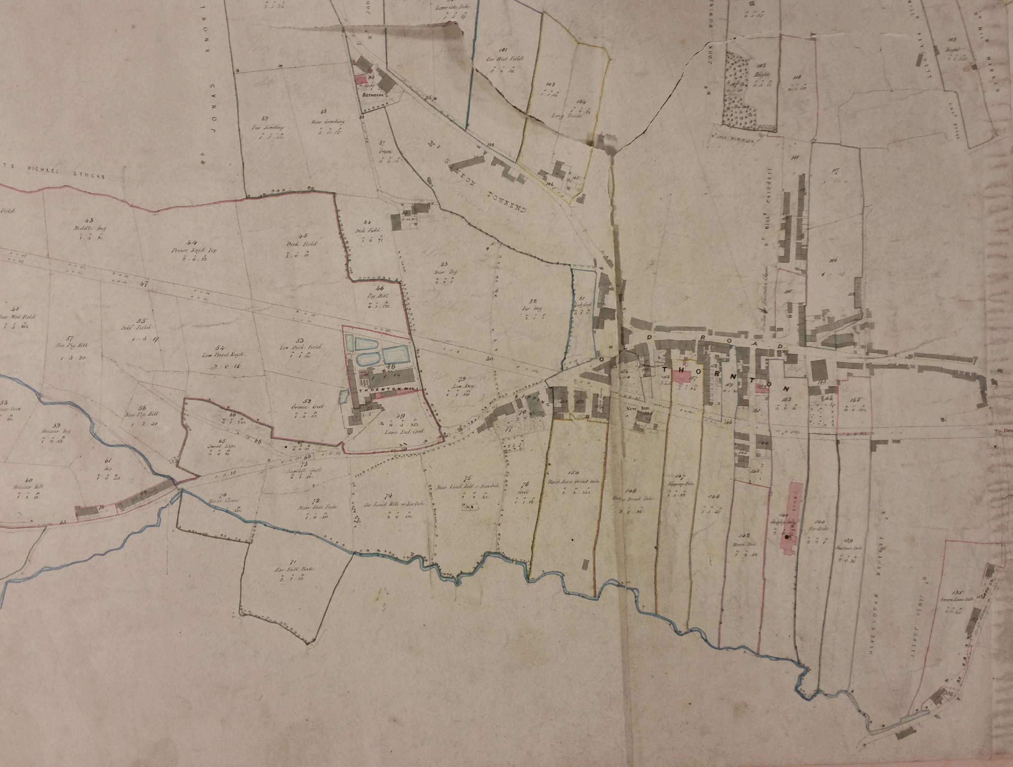
In the LSL there is also this second, undated but older, map entitled ‘Miss Firth’s estate’; underneath this printed description someone has added, in ink script, ‘Rev J C Franks estate’. Underneath this in turn is a single word in pencil which may be ‘Occupiers’ but is too faint for certainty. If the map is consistent then land-owners of property adjacent to the estate are added in ink, and pencilled names, scarcely legible here, might be the estate tenants.
The use of a first name for Miss Firth would have helped the process of identification enormously. We have the 1770 enclosure map for Thornton which suggests that this estate was on land enclosed before the passing of the late eighteenth century Enclosure Act. One of the names of those subsequently awarded parts of the common was a Dr John Firth. William Cudworth in Round About Bradford mentions a Firth family, and in particular a Joshua Firth, living at nearby Allerton Hall in 1777. In 2009 the Thornton Antiquarian Society published Thornton 1751-1938 which is a fascinating collection of newspaper items mentioning the area which was collected by historian Jean K Brown. One from the Leeds Mercury in 1823 mentions that Kipping Mansion House was ‘presently occupied by Mrs Firth’. I can find a Miss Firth in Land Tax Records for 1821 and 1823 but since no first name is provided there either I’m not much further forward.
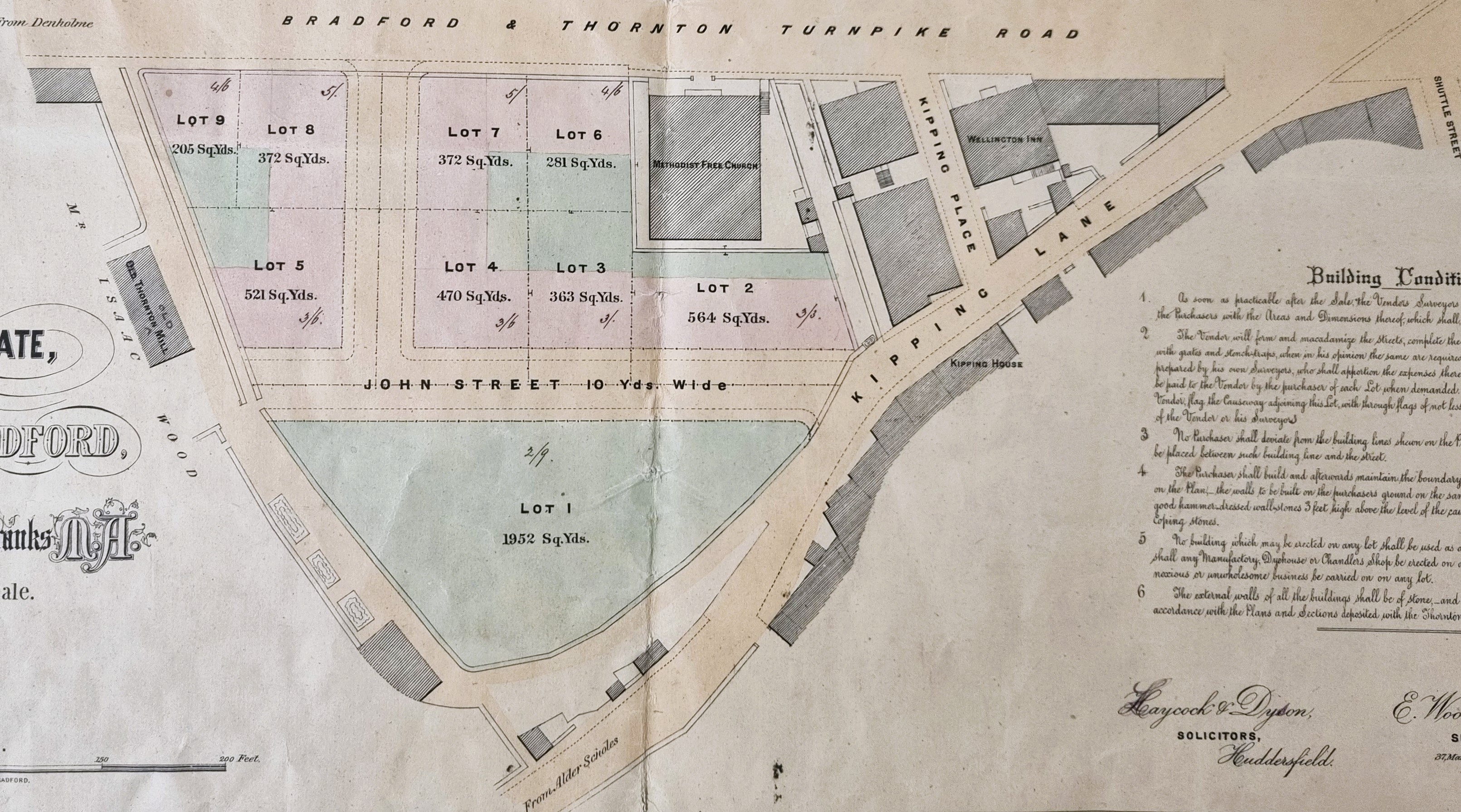
The new point of interest I have found in the main map can be seen in this detail. In the top centre of the detail is a building described as Methodist Free Church. For the last two years I have been trying to draw up a register of Victorian places of worship and locate them on LSL maps and images. I have found 4-5 Methodist Free Churches, the nearest to this being at Egypt a hamlet north of Thornton, famous for ‘the walls of Jericho’. Historian William Cudworth writes that the ‘present chapel’ originally formed part of the circuit of Wesleyan Reformers but 11 years before he published Round About Bradford it was joined to the Bradford Circuit of the United Methodist Free Churches (an amalgamation of Wesleyan Reformers with the Wesleyan Association). In the 1914 OS map it has become the United Methodist Chapel, and I believe it is still present today but converted into two domestic dwellings.
The church was constructed in 1857 and, as you can easily see, is aligned on the turnpike – now Thornton Road. The two properties to the right, one the Wellington Inn, are not aligned like this and so are very easy to spot on maps. That being the case you can see that the land boundaries have not changed between Miss Firth’s plan (blue outline) and Rev. Franks plan but none of the properties with Thornton Road frontages had been constructed when the older plan was surveyed.


I am delighted reading about Kipping House. If you could kindly e-mail me, I would love to share some of my Family´s information about this property. I am Sara Elizabeth Franks. The Reverend James Clarke Franks and his wife, Elizabeth (neé Firth) Franks, are my 2nd Great Grand Parents.
LikeLike
Miss Firth was Elizabeth Firth, friend of the Brontë family.
LikeLike
It’s interesting to see this map and the names of streets. I was previously aware of the sale advertised in the Bradford Observer of 11 January 1866, but it is interesting to note in the Bradford Observer of 8 March 1869 a report of the Thornton Local Board which approved a new street, to be called James Street, to run from the Waterworks Reservoir to New Road (the name then given for Thornton Road, as opposed to Old Road, the way to Thornton before the Turnpike road was completed in 1829). James Street was to be built by Theophilus Peel, who it appears bought some of Upper Kipping estate, as he sold a piece of land on George Street for the erection of a new Police Station which was built at number 1 George Street (now a dwelling). Within the area above Thornton Road, William Street was not built, but two additional streets were Mary Street between Firth Street and Henry Street and Peel Street, northwards from George Street, around plot 23, which I have always believed was named after Theophilus Peel rather than Robert Peel.
George Townend was the son of Simeon Townend who first brought steam power to the first textile mill of Thornton, a mill owned by David and Jonathan Wright. Simeon Townend married David Wright’s daughter Hannah, in 1823 by Archbishop’s licence in 1823. Another of Simeon’s sons was called Wright Townend. Simeon and Wright managed Thornton Mill (also known as New Mill) after their father’s sudden death in 1860. David Wright ran the Old Mill, at the end of John Street, shown on the map, until 1840 when that mill was sold to pay his creditors. Simeon Townend ran the mill until he managed to sell it, decades later, to Isaac Walton. Isaac Walton sold it to the Keighley and Skipton Building Society and Hugill Street, names after that Society’s Secretary, was built in the early 1900s.
The Methodist Free Church became unstable as a building, because of sagging walls, and the Methodists joined with Headrow Housing to build on the site, flats for the over 60s, and a church in the basement, at ground floor level from Chapel Street.
The map confirms where Shuttle Street was, named in the 1841 and 1851 censuses.
Clive Richardson, compiler of the All About Thornton website.
LikeLike
*George and Wright Townend managed Upper Mill for a few years after Simeon’s death, then Theophilus Peel took over until 1899. A year later Downs and Coulter bought the mill and Downs, Coulter operated the mill until its closure in 2002.
LikeLike