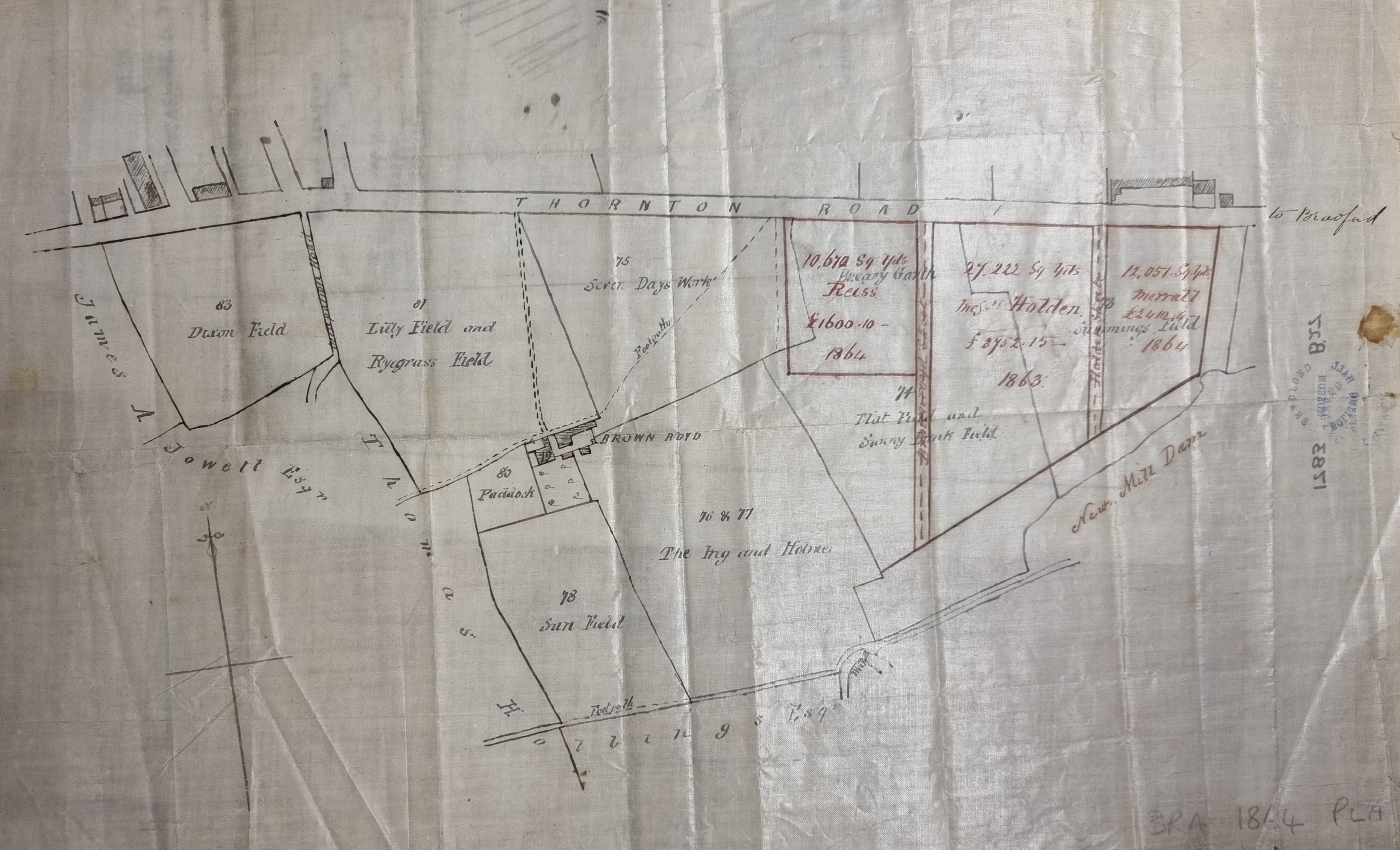
2.39 BRA 1864 PLA BHM 1783 B27
Oiled Paper Scale: unk
45*27cm Condition: good
This plan from the Bradford Local Studies Library reserve collection clearly deals with land ownership. It shows the area south of Thornton Road and west of New Mill Dam centred on Brown Royd Farm. The New Mill Dam and a small portion of the Bradford Beck (with weir) are drawn towards the bottom. The plan indicates land purchase by Reiss, Holden and Merrall in 1863-64, and the creation of two new streets. Other land-owners named are Thomas Hollings Esq and James A Jowett Esq. Nathan Jowett, father of James Atkinson Jowett (1817-1886), inherited the Clockhouse Estate in maturity from his relative George Baron but a rival claimant ensured that there were years of litigation. Thomas Hollins or Hollings is probably the man who Cudworth reports lived at West House, Toller Lane and was a stuff manufacturer, or his son of the same name.
The pattern of buildings and fields closely resembles the 1851 OS map. By the next edition in the 1880s development had changed the appearance of this area out of all recognition. In what sense does the plan show transition? It is quite evident that much land occupied by the modern city of Bradford must once have been farmland. Here the plan indicates the superimposition of new land holdings on a different alignment to the existing field boundaries. I assume that the fields were part of Brown Royd Farm. Even the original field names are preserved: Dixon Field, Lily Field, Ryegrass Field, Seven Days Work, Sun Field, the Ing and Homes, Flat Field, Sunny Bank Field, Summings Field, and Breary Garth. The names of the fields reflects the time taken to work the parcel of land, the name of the owner, the plants growing on it, and even the weather condition. Ing is a common name, of Old Norse origin (eng), for a meadow and garth is an alternative name, also of Norse origin, for an enclosed parcel of land.
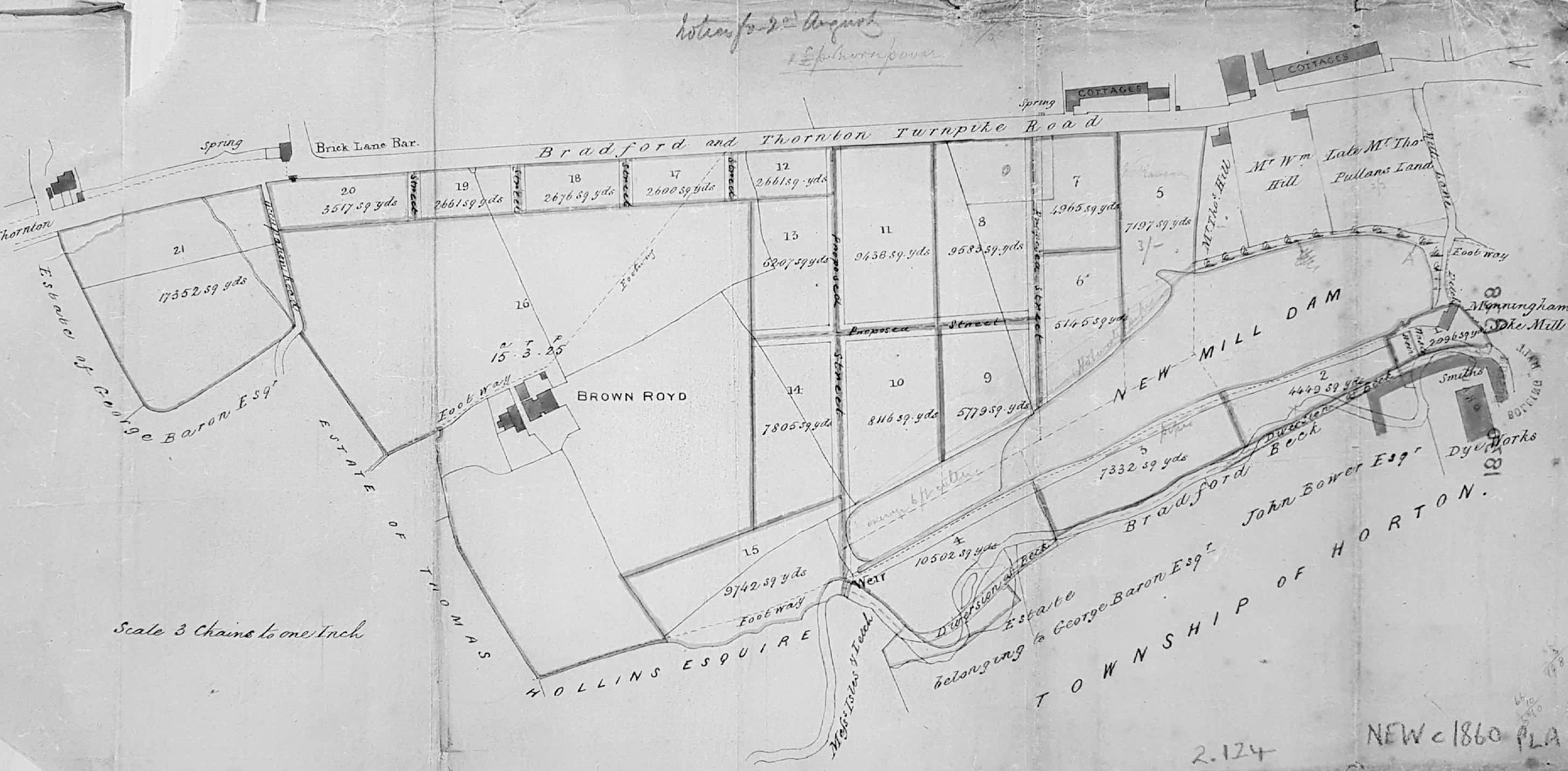
At a guess the second plan (2.124 MAN c1860 PLA) is from a decade later. The process is evidently advanced but the field names are no longer recorded. This plan also shows the land south of the Bradford & Thornton Turnpike Road (Thornton Road) divided up for sale and perhaps development. This road appears horizontal on the plan but, in reality, runs slightly deflected to the north-west. The Brick Lane Bar at the top left was a place for toll collection. It is not very near Brick Lane but is located at the junction with Whetley Lane. Opposite today is the Girlington branch of Morrisons.
The buildings at the top right are two rows of cottages separated by the New Mill Dam Inn. You can see that Brown Royd (Farm), Smith’s Dye Works, Manningham Soke Mill and the Bradford Beck are clearly labelled. The map is undated. There are pencil annotations which are unhelpful. The overall distribution of buildings and field boundaries still resemble the 1851 OS map including a Beck diversion which could have formed part of this scheme.
Smiths Dye Works is now a prominent building at the bottom right. In the OS map a dye-works of a somewhat different foot print is called Field Dye Works but we are looking at the same enterprise namely: Samuel Smith, stuff dyer, who in an 1850 directory was located at Field Dyehouse, Thornton Road. Cudworth records that the New Mill(er) Dam was created by John Smyth of Heath, near Wakefield, around 1777. His family were associated with Miryshay off Barkerend Road.

